Preliminary Migration Overview
February 2013The North Atlantic jetstream continues to lurch and wobble on its way, as has been the case since this time last year. At present it is giving unsettled weather over most of the British Isles, and triggering thunderstorms today in southern Italy.
Its counterpart over the Sahara is still further north than usual. A seasonal blocking anti-cyclone east of the Azores continues in place. (The arrows on the chart are NOT surface winds, they are the high-altitude jetstream circulation.)
Conditions over west Africa and western Europe are not favourable for early migrants, with contrary winds at low levels and the westerly and northerly airstreams holding temperatures down. General visibility over NW Europe is poor.
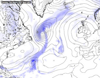
In the coming weeks, we would like to see a weather picture developing similar to this...
... which was the surface chart last year (9th March), when high pressure over Britain, the western Med, and north Africa enabled birds to make good progress towards "home". Monty reached Wales on the 2nd April, but it was the situation shown here which enabled him to get moving.
I will blog again in a few weeks time, when the picture should be getting a little clearer.


No comments:
Post a Comment